Bere Ferrers Station to Gnatham & River Tavy Circular Walk with an optional extension to Lopwell Dam

Easy

3 miles (4.8km); with extension to Lopwell Dam 5 miles (8km)

1½ hours; with extension to Lopwell Dam 2½ hours

The creation of this walking route has been led by the Tamara Landscape Partnership Scheme, a project run by the Tamar Valley National Landscape and funded by the National Lottery Heritage Fund.

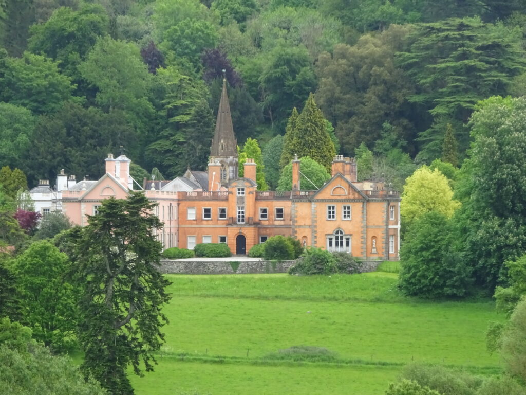
Maristow House
A gentle exploration of the picturesque village of Bere Ferrers and the creek at Gnatham on the west bank of the Tavy estuary, with a there-and-back extension to Lopwell Dam.
SUMMARY

Step back in time on this gentle amble around the peaceful village of Bere Ferrers, located on the east side of the Bere peninsula. Spotting the village’s location on the map informs the origins of the first element of its name: ‘Bere’ is a Celtic word, meaning peninsula or spit of land. ‘Ferrers’ comes from the Ferrers family, Lords of the Manor in the time of Henry II (reigned 1154–1189). Allow time to have a proper look at St Andrew’s Church, which dates from the 13th century; the east window contains some of the earliest stained glass to be found in Devon.

KEY FACTS

Start/Finish

Bere Ferrers Station SX 452635, PL20 7JR

Distance

3 miles (4.8km); with extension to Lopwell Dam 5 miles (8km)

Time

1½ hours; with extension to Lopwell Dam 2½ hours

Terrain

Field paths and quiet lanes; steady ascent/descent on Lopwell Dam extension (areas of bare rock, slippery in wet); damp underfoot at Gnatham

Difficulty Rating

Easy

Toilets

Behind The Olde Plough Inn, Bere Ferrers

Parking

Public Transport

Rail services Tamar Valley Line to/from Gunnislake and Plymouth; bus services to/from Bere Alston and Tavistock

Dogs

Under control at all times; on leads at the Coach House

Directions

1 SX 452635

From the station – on the main line between Plymouth and London Waterloo from 1890 until the 1960s (the branch line to Gunnislake was retained as the Tamar Valley Line) – head down the access road. On reaching Station Road turn right; within a few paces, at a public footpath sign, turn sharp left on a drive leading to four properties. Another footpath sign directs you straight on at the entrance to the Coach House: follow the drive through the beautiful woodland garden (dogs on leads). At the house bear left across the lawn, clipping the end of a beech hedge, to find a small gate in the hedge. Follow the wire-fenced footpath right then left across a big pasture field. At the bottom turn left to find a gate onto the lane. Turn right for 50 yards.

2 SX 454639

Turn left over a ladder stile at a public footpath sign. Once in the field keep ahead through a gate and cross a stream, then head uphill to cross a stile at the top corner of woodland on the right. Follow the narrow path along the top edge of the wood. Cross another stile; the permissive path bears left, then runs along a bank between fields. At the end pass an open-fronted shed, then walk along a tree-lined track. Bear left at the end, then turn right – note ‘John’s Orchard’ on the left – to drop past the entrance to Shutecombe Farm, where daffodils were grown commercially in the 1800s and early 1900s. Follow the farm drive to meet Hensbury Lane on a bend.

3 SX 459637

Turn left, signed to Hallowell – the name may derive from an early ‘holy well’ in the locality – and Gnatham, and walk gently uphill, soon enjoying lovely views across the Tavy to Blaxton Wood over occasional field gates. Pass a lane to Hole and keep straight on; the lane descends, joining the Tamara Coast-to-Coast Way (TCCW), and crosses a stream (about 75 yards before the stream the TCCW heads sharp right – if you find the creekside path at Gnatham on Point 4 too wet, return to this point and follow the TCCW to Bere Ferrers). Follow the lane uphill to meet a junction with a dead end lane on the first bend.

4 SX 465641

EXTENSION TO LOPWELL DAM Continue along the lane, ascending steadily. The gradient eases a little alongside a lovely run of oak and hawthorn. Opposite a big barn turn right down a track signed to Lopwell Dam. Descend through beautiful Whittacliffe Wood to reach the dam – it’s fun to cross over on the narrow walkway (impassable for two hours either side of high tide). Lopwell Dam – constructed in 1953 to boost Plymouth’s water supplies – is a tranquil spot today, at the tidal and navigable limit of the Tavy. Mining for silver and lead in this area dates back to the 13th century; Wheal Maristow, in the woods, was worked again in the 19th century. It is recorded that in the early 20th century the Vivian brothers lived in a cottage nearby (now in ruins) and ferried people across the river in a wooden rowing boat. The surrounding area (a Site of Special Scientific Interest and Local Nature Reserve) is known today for its plentiful wildlife, attracted by a range of habitats: woodland, marshes – both freshwater and saltwater – and mudflats. Retrace your steps to Point 4. MAIN WALK Turn left, downhill, to pass derelict cottages and reach the river below Gnatham Farm. Turn right onto the muddy track, then step up onto the marshy ground on the right to cross the bridge over the stream. Bear left to reach a footpath marker post on the track ahead, joining the TCCW. Here bear right, away from the (at times) very wet track, to follow a narrow path that parallels the estuary. Eventually round a stile to re-join the track and keep ahead: houses at the lower end of Bere Ferrers, and the church, come into view.

5 SX 460636

Reach a lane and head on to pass the quay (a lovely place to sit – you can see Maristow House, dating from 1760, upriver on the other side of the estuary). Follow the lane uphill past The Olde Plough (16th century), to reach the war memorial and ‘megalithic’ well, commissioned by Frances Lady Shelley ‘for the benefit of the poor in her son’s parish 1852’ (to visit St Andrew’s Church, dating from the 13th century, turn left here – the wonderful ‘living churchyard’ is home to all manner of wildflowers, grasses, butterflies, birds (including swifts in summer), and daytime species of moths). Continue uphill through the village.

6 SX 457635

Turn left along Station Road, passing St Andrew’s Church Hall (built as the village school in 1896). Head steadily uphill; at the top follow the road round to the right to reach the station.

Map

All Short Walks

Whether you’re an avid hiker eager for a week-long adventure tracing the Tamar River from sea to source or just looking for a short stroll to a cosy pub, there’s something for everyone. 

Find out more about our marvellous landscape by visiting the Tamar Valley National Landscape’s website. 

Filter by Difficulty

Filter by Town

NEar by